『Xinjiang on Silk Road』
Urumqi
Urumqi, the capital city of the Xinjiang Uygur Autonomous region, is
sitting on an alluvial fan at the northern foot of the Tianshan
mountains, with the Junger basin in the north and surrounded by mountain
ranges in the east, west and south. The Urumqi river flows through it
from south to north. Covering an area of 11,440 square kilometers with
an elevation of 680 to 920 meters, urumqi is the political, economic,
cultural, science and technological center of the xinjiang autonomous
region, as well as the hub of communications linking
the region with the rest of the country.The place where Urumqi stands
was a pastureland in ancient times, but during the sui dynasty, trade
began to be conducted between the region and the interior of the
country, which further brought in the advanced civilization from the
central plains. During the tang dynasty, troops were stationed in the
urumqi area to develop the land and to build frontier fortifications.
During the Ming dynasty, a city was set up in the present Jiujiawan
district of urumqi, but it was destroyed by fire in the junger
rebellion. in 1760’s, a new city was built and named " Dihua", which, in
Chinese, means "enlightening and civilizing". In 1884, the Xinjiang
province was established and dihua city became its capital. In 1954,
five years after liberation, the city was renamed urumqi.
Urumqi has a population of 1.5 million, including the Uygur, Han, Hui,
Kazak, Manchu, Mongol, Xibe, Russian and other ethnic people. The annual
mean temperature in Urumqi is 7.3 centigrade but the highest
temperature in history was 42.1 centigrade and the lowest was -41.5
centigrade.\
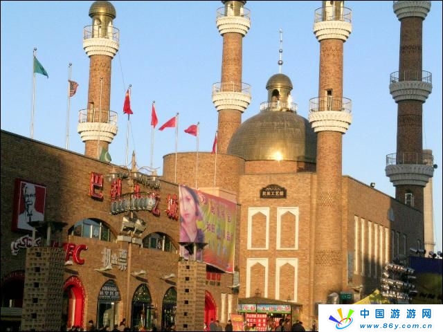
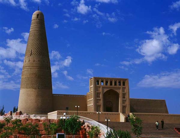
SuGong Tower
Sugong tower,also called "emin tower" and "the Turpan tower" by the
local uygur people, is located 2 kilometers east of the city of Turpan.
Built in 1778, it is the biggest tower in xinjiang and has an
architectural style all its own.
In the shape of a cone and
built of bricks arranged in fifteen patterns of rhombuses, ripples,
varied four-petal flowers, and mountains, The tower is 37 meters high
and 10 meters in diameter at the base. The tower has 14 windows opened
in different directions and at different heights and a
seventy-one-stepped spiral flight of stairs leading to the top.
At
the entrance of the tower stands a stone tablet erected when the tower
was built, on which is recorded, in Uygur and Chinese, the reasons for
building the tower.
Next to the tower is the biggest mosque in the Turpan area, and the two form an integral whole. The rectangular mosque has a hall in its middle and an arched gate with a pointed top. The hall can hold as many as one thousand people attending service.
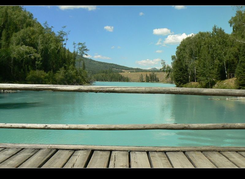
TianChi Lake
Sprawling on the waist of mount bogda of Tianshan mountains and 100 km east of urumqi, Tianchi lake, like a sparkling pearl imbedded in tianshan mountain, runs 4,9 square km wide and 90 meters deep. It is a moraine lake fed by thawing snow runoffs and is about 1,980 meters above sea level. Snow-mantled peaks and sky-soaring dragon-spruce are among other things that define tianchi as a scenic place with prismatic splendor.

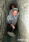
The Karez System
The karez system is an irrigation system made by well-connected
underground channels. There are in the turpan area nearly one thousand
karez totaling 5000 kilometers in length.
The structure of the Karez
basically consists of wells, underground channels, ground canals and
small reservoirs. In spring and summer, a great mount of melting snow
and rainfall flow down from the Bogda and Karawuquntag mountains north
and west of the Turpan basin into the valleys and then seep into the
gobi desert. Taking advantage of the mountain slopes, the working people
ingeniously created the karez to draw the underground water to irrigate
the farmland. The water in karez will not evaporate in large quantities
even under the scorching heat and fierce wind, hence ensuring a stable
water flow for irrigation.
As
far back as the Han dynasty, the Karez was recorded in shi ji (the
historical records) and then called "well canals". Most of the existing
karezes in the turpan area were built in the Qing dynasty. nowadays,
large stretches of fertile land are still irrigated by karezes. The
Wudaolin Karez and the Karez in the Wuxing town are open to visitors.
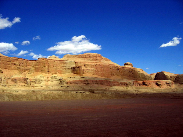
Flaming Mountain
The flaming mountains, lying in the middle of the Turpan basin and
stretching from east to west, are one of the branch ranges of the
Tianshan mountains and were formed in the organic movements of the
Himalayas fifty million years ago.
In millions of years, the
natural weathering and the numerous folded belts caused by the crust
movements have formed the undulating surface of the mountains with the
crisscross gullies and ravines. Under the blazing sun, the red rock
glows and hot air curls up like smoke as if it were on fire, hence its
name. The mountains are 98 kilometers long and 9 kilometers wide. The
highest peak is 40 kilometers east of the city of Turpan and 831.7 meters
above sea level.The flaming mountains are so hot and so dry that "
flying birds even 500 kilometers away dare not to come". Yet, the
mountains at the same time act like a giant natural dam of the
underground reservoir in the basin.
Situated on the north
route of the ancient silk road, the flaming mountains have many cultural
relics and often told ancient tales.
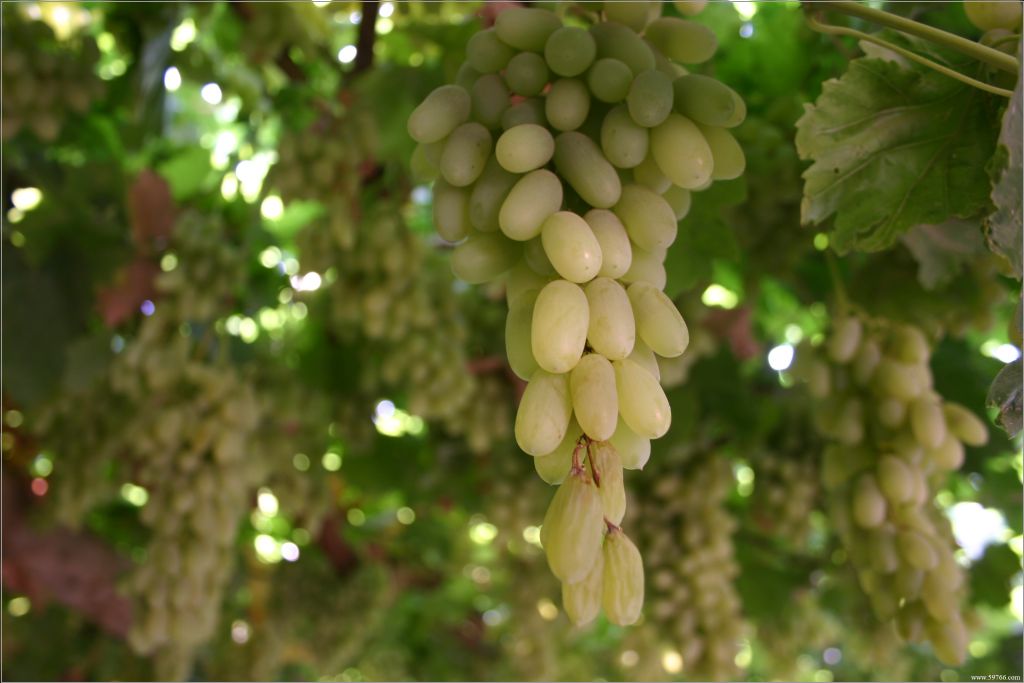
The Grape Valley
Looking at the flaming mountains from a far place, one can see nothing
but glowing, barren red sand. But the grape valley of the flaming
mountains, 15 kilometers from the city center, is a world of unique
beauty, presenting a striking contrast with the hot, dry and barren
outside.
With green grass and green trees, the valley is a world of
green with singing streams, canals and sparkling springs. There is a
poetic flavor to the idyllic beauty of the valley. Scattered everywhere
in the valley are trees, such as mulberry, peach, apricot, apple,
pomegranate, pear, fig, walnut and so on, as well as watermelons and
muskmelons. All these make the valley into a fruit garden with blooming
flowers in spring and many kinds of fruits in summer. In the valley there
is a reception center where dense grapevines interweave with each other
and shadowing paths lead to inner place of the green world with
clusters of grapes within reach.8 kilometers long, half a kilometer wide
and inhabited by about 6,000 people of the uygur, hui and han
nationalities, the grape valley has more than 400 hectares of cultivated
land, 220 hectares of which is grape-growing area. grapes growing here
are of several strains, including the seedless white, rose-pink,
mare-teat, black, kashihar, bijiagan and suosuo.
Beziklik Thousand-buddha Grottoes
The beziklik thousand-buddha grottoes, 48 kilometers northeast of the turpan, are located in the flaming mountains' mutou valley. There are 77 numbered grottoes, about 40 of which still have murals in them. With a total of 1,200 square meters of murals, the group of grottoes in beziklik has the most grottoes, most diversified architectural styles and the richest mural content in the turpan area. The grottoes were hewn in the period of several centuries from the tang dynasty right up to the yuan dynasty in the thirteenth century.
Today,
one can still see on the remaining buddhist murals the features of the
king and queen of huihu and people of different status, as well as
scenes of the lives of ancient uygur people. Inscriptions in the ancient
huihu, chinese and brahmi languages are valuable materials for the
research on the written languages and history of xinjiang's various
nationalities, and uygur in particular.
The bizaklik thousand-buddha caves became an important cultural unit protected by the state in 1961.
GaoChang Ancient Town
The ancient city of gaochang is located near the seat of the "flaming mountains" township 46 kilometers southeast of the city of turpan. the city walls are high and the crisscrossing streets and the city moat are still visible. the city walls, which are basically intact, divide the city into three parts: the inner city, the outer city and the palace city. The 5.4 kilometer-long wall of the square outer city is 11.5 meters high and 12 meters thick. The wall is built of tamped earth, with some
section
repaired with adobe. There are two gates on each side of the outer city
and the two on the west side with defence enclosures outside the gates
are the best preserved.
The inner city, which is located in the
center of the outer city, has a 3-kilometer long wall, most of the west
and the east sections of which are well preserved.
The rectangular palace
city is in the northern part of the city of gaochang and it shares the
north wall with the outer city and uses the north wall of the inner city
as its south wall. There are still several 3 to 4 meters high earthen
platforms in the palace city where the court of huigu gaochang kingdom
was seated.
In the north central part of the inner city,
there is a high terrace on which stands a square pagoda built of adobe
called "khan's castle" which means "imperial palace". Somewhat to its
west there is a half-underground, two-story structure which was probably
the ruins of a palace.
In the southwestern part of the
outer city there is a temple which is 130 meters long from east to west,
85 meters wide from south to north and covers an area of 10,000 square
meters. The temple consists of an arched gate, courtyard, a lecture
hall, a library of sutras, a main hall and the monks' dormitory. murals
remaining in the main hall are still visible. The renowned buddhist monk
xuanzang of the tang dynasty is said to have lectured in the temple for
more than one month in the year 628 on his way to india to obtain
buddhist scriptures. In the vicinity of the temple there are also ruins
of workshops and market sites. In the southeastern part of the outer
city there is a smaller temple, the ruins of the murals within which are
better than those in the main hall.
The construction of the
city of gaochang started in the first century b.c. first called
gaochangbi, it was a key point on the ancient silk road, but after many
changes in fortune over a period of 1,300 years, and under the
jurisdictions of the gaochang prefecture, the gaochang kingdom and
huozhou prefecture, the city was burnt down in wars in the fourteenth
century.
It was classified as an important cultural unit protected by the state in 1961.
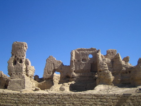
JiaoHe Ancient Town
The ancient city of jiaohe is located in the Yarnaz valley thirteen
kilometers west of Turpan. It was the capital of the state of south
yarkhoto, which was one of the thirty-six states in the western region.
Bounded by two rivers, thus the city was named jiaohe, which means
“confluence of two rivers”. Built on a loess plateau 30 meters high, the
ancient city is 1,650 meters long and 300 meters wide. The city has no
walls and is protected by the natural fortification of the precipitous
cliffs.
During the western han dynasty, the central government established "Jiaohebi" (an administrative division) and dispatched commanding officers
to the Turpan area. During the period from the northern wei to the
beginning of the tang dynasty, jiaohebi belonged jiaohe prefecture under
the jurisdiction of gaochang kingdom. the xiyu military viceroy's
office, the highest civil and military administrative organ set up by
the tang government in the western region, was first established in the
city. After that time, it was called jiaohe prefecture and fell under
the jurisdiction of the huihu Gaochang kingdom. At the end of the
thirteenth century, it was destroyed in mongolian aristocratic
rebellions.
Today, debris and dilapidated walls and bare
foundations are what remain of the place, but the inexorable pace of
history is nevertheless keenly felt from the city layout and vestiges of
yamens, monasteries, pagodas and back alleys.
Sayram Lake
With an altitude of 2,073 meters above sea level, the
450-square-kilometer Sayram lake to the southwest of bole is xinjiang’s
largest alpine lake. The grasslands and mountain slopes ashore are
studded with yurts, while big herds of cattle and sheep graze in the
meadows. during the nadam festival, here is the site of a variety of
merrymaking activities.